06/12/24
02/12/2024
🎥 Aerial Drone Filming of the Annual Bolsover Lantern Parade – Captured by LeesHoverVision
LeesHoverVision.com was proud to be commissioned for aerial drone filming and photography of the Annual Lantern Parade in Bolsover, Derbyshire – a magical community event that lights up the historic streets each year.
The Lantern Parade begins at the iconic Bolsover Castle and winds its way through the town, finishing in Bolsover town centre. The entire route takes approximately 30 minutes to complete, requiring precise planning and perfect drone timing to ensure every key moment is captured from the air.
As a CAA-approved commercial drone operator, I had to carefully monitor drone battery levels and weather conditions to ensure I was ready to film the exact moment the parade emerged from the castle gates. Timing is everything when capturing live public events like this, especially during low-light conditions in the evening.
The full aerial video of the Bolsover Lantern Parade is coming soon – stay tuned!
Below are some aerial drone photographs of the event.


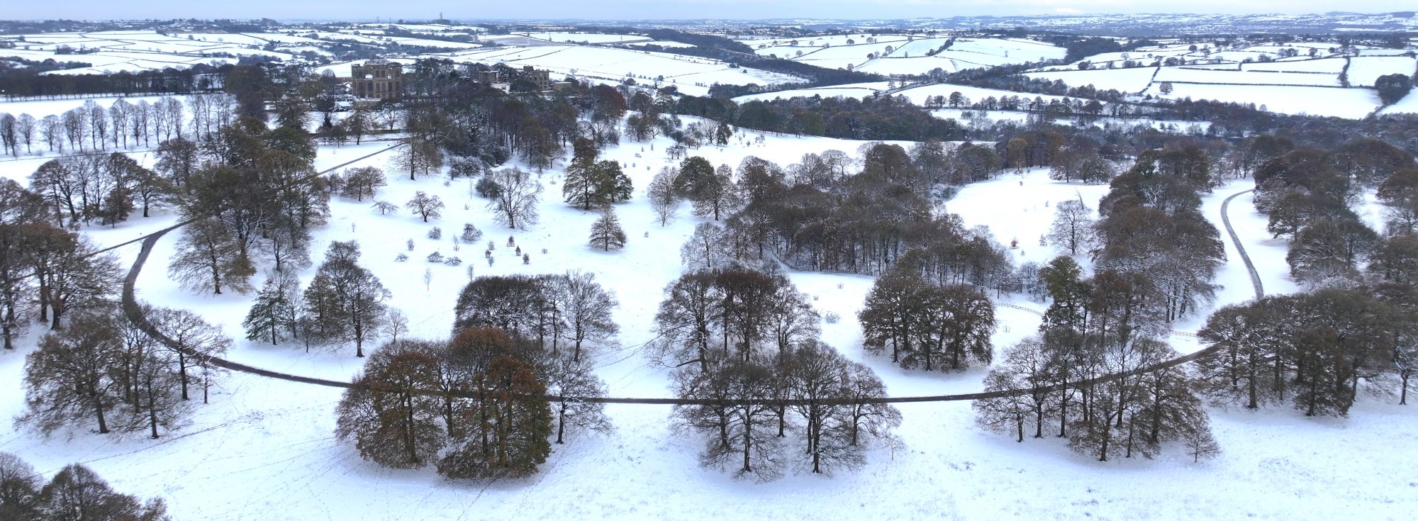
21/11/2024
When it snows I’m called upon by a client to capture the district from above laden in snow I must act quickly before it melts and it melts rather quickly in the Midlands UK, you’re lucky if it stays around for a couple of days.
Below are some aerial drone filming clips I filmed from around the district. Only made possible by drone technology.
08/11/2024
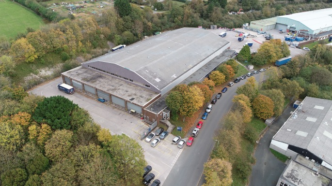
leeshovervision.com has been contacted to advertise and help sell a large Industrial distribution unit in Derbyshire. This large premises required drone aerial photography to help identify the location that it is situated in along with the scale of the building this is only made possible by using drone technology.
Below are a few drone aerial photographs of the large building.


16/05/2024
leeshovervision.com has been contacted to advertise and help sell some distribution units in Derbyshire. These warehouse units needed drone aerial photography to help identify the location that they are situated in. Only made possible by using drone technology.
Below are a few drone aerial photographs which were taken that day.


11/03/2024
leeshovervision.com drone surveys has been called out to inspect a commercial roof on a building in the midlands Derbyshire which was impossible to reach with a scissor lift and the quotation from a scaffolding company was far to expensive. The client wanted a drone survey carrying out of the defect areas of the commercial roof and within minutes the drones zoom lens camera was able to identify the defect areas.
Using drones to inspect at hights will always be more quicker, safer and cost affective for the client. The accurate data for the client will be turned around on the same day or at very latest the next working day. Below are a few aerial drone photographs taken from the drone roof survey.


08/03/2024
leeshovervision.com has been called out to take some drone aerial photographs in Derby. It can be rather tricky this time of year as the sun is low in the sky, earlier darker nights and if it’s not raining its far to windy. But on the positive side you get a couple of good days like the images below. Only made possible by drone aerial photography.


07/03/2024
leeshovervision.com is updating several sites across the district below are a couple of drone aerial photographs showcasing the ongoing progress at this site in Derbyshire. Only made possible by aerial drone photography and filming.


05/03/2024
leeshovervision.com has been updating some construction sites in Derby for a client who is keen to see the ongoing structures being built over time. You can only achieve these kind of angles and shots by using drone technology. Below are a few images from the ongoing site progression in Derby.


09/02/2024
leeshovervision.com was called upon to inspect a roof property in north Wales which had a water leak coming from the roof area. After carrying out a drone roof survey of the premises we identified there was a crack on one of the roofs tiles which lead to water leaking into the one of the bedrooms on the top floor.
The client wanted a drone roof survey as he enquired about hiring out a scissor lift but he was quoted a higher fee than using one of our drones to inspect the roof. Not to mention the road would of had to be closed off as there was traffic passing by near the house.
To safely carry out the drone roof inspection we had to be on site at first light and make this happen on a Sunday morning as this limited the amount of traffic and footfall ensuring saftey first which comes as standard as always with leeshovervision.com
below is a few images from the drone roof survey.


07/12/2023
leeshovervision.com was tasked with drone filming and photographing the lantern Parade along with the Bright Winter Nights event held at Bolsover Castle over the weekend. Below are a few aerial drone photographs showcasing the lights from above. Only made possible by drone technology.


21/11/2023
leeshovervision.com was called upon to film and photograph the Clowne Half Marathon in Derbyshire. It was a great turn out with many people involved the quickest runner made a time of 75 minutes to run 13 miles a super fast time indeed.
Aerial drone photography alongside aerial drone filming made capturing the event more pleasing to the eye as ground footage was limited.


19/10/2023
leeshovervision.com will be filming a newly built development site in Shirebrook Nottinghamshire throughout its stages. All the data will be captured and collected with drone aerial photography and drone aerial filming. Below are a few drone images from the starting phase of the development site.


12/09/2023
leeshovervision.com was tasked to film and photograph the Legendary jousting event held at Bolsover Castle this summer. The weather held out to use the drone, it was a great day for all those involved. Below you can find some images and a trailer video from the day.


08/09/2023
Rapid progress at Horizon 29. Here are a few images taken from the drone footage showcasing the entire site which is around 100 acres only made possible by drone photography along with drone aerial filming. A few updated images are below.


13/06/2023
leeshovervision.com was called upon to carry out a drone roof survey on a church roof in Derbyshire. This was only made possible with drone technology as the ground surrounding the church was unfit for a scissor lift and the quote for scaffolding was far too expensive to erect around the old church. A drone roof inspection was the only way forward on this type of building. The images are below.


31/05/2023
leeshovervision.com was asked to take ongoing drone aerial photography of a few sites in Derby. Using drones to collect data of this nature is the only way to accurately see the ongoing progress made at these sites pictured below.


04/05/2023
leeshovervision.com was asked to drone film the Miners unveiling day in Shirebrook by Channel 4 and Shirebrook town council. This consisted of a parade walking through the streets making the way to the town center where the unveiling of the monument took place. Lots of planning was needed to ensure that the drone would be in the line of site at all times. This was made possible whilst using the DJI Mavic 3 with its x7 optical zoom range of 166mm which made the drone filming easier than if I would have used a 24mm fixed lens.
Below are a few drone aerial photographs of the miners unveiling day along with the video.


21/04/2023
The latest drone aerial photography from leeshovervision.com was based in Derbyshire showcasing a plot of land for sale and development along with the whole site in context to the motorway to help identify the location. Aerial photography showcasing the images below is only made possible by drone technology.


23/03/2023
Drone roof surveys and inspections.
Aerial drone roof surveys and inspections using the latest drone technology do help greatly overcome problems associated with expenses and can be carried out safely, quickly, and efficiently at low cost. Drone Surveys are safer, faster and cost-effective
https://leeshovervision.com/inspections/ are qualified and registered with the CAA. We are fully insured for commercial operations and carry out a risk assessment prior to each project to ensure the drone survey is carried out safely.
What’s included in the roof survey report?
The drone roof survey will include a detailed inspection using the latest drone technology aerial photography to report on the following: Overall condition, damage to roof tiles or slates, gutters and rainwater system, repairs, leaks, roof spread and sag, blockages, leaking joints, mortar areas, cracked glass and install quality to windows and skylights, valleys, chimney condition including flaunching, brickwork, pots and leadwork.
21/03/2023
https://leeshovervision.com/inspections/ drone roof surveys were contacted to inspect the gutters, newly fitted roof lights and the general condition of the commercial roof. This was only made possible using a drone to collect the relevant defect areas which needed more attention to detail like in the aerial photography attached below.


15/03/2023
https://leeshovervision.com/commercial/ was tasked to collect some snowy scenery aerial photography along with aerial footage in the Northeast Derbyshire district. This was very challenging indeed as the snow was gone in two days which seems to be the case in this country not to mention getting to some of the chosen locations. Below are a few aerial photographs from some of the locations chosen.


08/03/2023
Here are a few aerial drone images taken of the ongoing progress at Horizon 29 Markham Vale Bolsover. I will also be filming this throughout its development stages.


03/03/2023
Drone aerial photography was used to help sell some of the units situated in the commercial business park in Doncaster. Drone photography is key when advertising these types of properties.


01/11/2022
Collecting seasonal footage from above of my local district town of Bolsover. This video has taken one year to make flying the same flight paths with my drones over each season to capture the changes that it brings. Only made possible by drone technology.
14/10/2022
It’s now Autumn time so here are a few aerial photographs of the changing colours at Poulter Country Park in Derbyshire. Using the drone to capture the entire place showcases this great from the air. It’s just not possible from ground level, it’s either a drone, helicopter or a plane to capture this as a whole.


10/10/2022
leeshovervision.com was aked to film and photograph the National Ploughing Championships 2022 in Glapwell Derbyshire. Below you will find the video highlights of the weekend. Using drones at these types of events really does capture the whole site along with some ground videography it gels together quite nicely.
09/05/2022
leeshovervision.com also provides ground filming/photography as well as aerial based drone work. I was called upon to capture and create the on site workings of a robot arm for a promotional video showcasing it through its packaging stages.
Below you will find the final version of the promotional video.
02/03/2022
https://leeshovervision.com/commercial/ has been called out for the second and final phase of the newly buit Alloga AP8 warehouse in Derby.
The final drone video consists of a day and night switch following the same flight paths along with aerail photography, drone filming, internal ground photography and videography. The video is shown below and the timings had to be perfect on this one.
07/02/2022
https://leeshovervision.com/commercial/ has been called out to film from the air using drone technology to update the housing development in progress, this was the third visit to the site capturing an aerial timelapse from start point to the final finished site.
Below is the aerial timelapse showcasing the old site onto the newly ongoing housing development. Only made possible by drone technology, aerial photography and drone filming.
31/01/2022
https://leeshovervision.com/inspections/ was tasked to carry out a drone roof survey and inspection on a stately home in the English countryside.
Using drone technology to inspect and survey these types of premises is quicker, safer and more cost affective than using the traditional method such as scaffolding or hiring a scissor lift/cherry picker.
Below are a few drone photograph examples which make the roof survey that little easier for the surveyor to then inspect from his computer in office instead of the traditional method mentioned previously and any defects found on the roof to then file in thier report.


30/11/2021
https://leeshovervision.com/commercial/ has returned for the second visit to Enterprise 36 to showcase the site now all 4 units have been completed. This perticular project was on an incline so ground cameras alone could not cover the scale of the site. But thanks to drone technology it is made possble to view the entire site with it’s surroundings in context. Below you will find the link showcasing Enterprise 36.
08/10/2021
https://leeshovervision.com/commercial/ collected lots of footage from ground to air of the local district and had the chance to edit some of those clips. Amongst the footage is the great landmark Bolsover Castle which I’ve had the pleasure to film inside and out a few times now. Below is the video showing parts of Bolsover from the drones perspective along with ground filming in the local district. Included in this video are some hyper lapses and motion lapses.
07/07/2021
https://leeshovervision.com/commercial/ was tasked to help a client who needed to put the Building below to market. Using aerial filming and aerial photography really helps when selling large buildings with plenty of land attached. You just can’t capture the site as a whole from ground based filming/photography without a drone.
10/06/2021
https://leeshovervision.com/commercial/ has been tasked to showcase a site in Derby using aerial photography along with aerial filming. The first video showcases the warehouse being filled with stock and the final video upon completion will have drone footage both day and night. The first short video is below.
08/02/2021
https://leeshovervision.com/commercial/ Has been tasked to showcase two units in Pontefract just recently. This time of year can be very challenging indeed for aerial drone work as most clients want sunny days, this must be planned with precision and timings as the sun is very low on the horizon which causes long shadows on the subject to be filmed and photographed.
Below is the video and aerial drone photography of the two units.


28/01/2021
https://leeshovervision.com/inspections/ Has been called upon to assess the extent of flood damage with all the snow and rainfall lately here in the UK.
Using aerial photography with drone technology in these scenarios is very beneficial as you can hover at appropriate altitudes to collect the relevant data necessary.


13/01/2021
https://leeshovervision.com/commercial/ Has been showcasing these large commercial warehouses which are to be put to market for potential buyers. These drone aerial photographs seen below make a great impact on potential commercial buyers as you can clearly see the entire development along with the motorway which runs in context along side of the site. Drone aerial photography is key when showcasing commercial units.


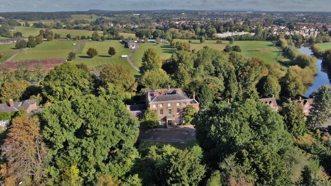
30/11/2020
https://leeshovervision.com/commercial/ Along with aerial drone photography leeshovervision also takes ground internal and external photography on any building which greatly helps when advertising the relevant project/build to market.
Recently I was tasked to help put to market the former birth place of Charles Darwin a very historical place indeed. Below are a few images of the large house and surrounding area this could only be achieved with drone aerial photography putting the house and land in context with its surroundings.


19-10-2020
https://leeshovervision.com/commercial/ Has been travelling all over the United Kingdom helping property developers market their retail and development sites from the best perspective.
Aerial drone photography really helps with capturing completed or ongoing site developments highlighting the surrounding context such as nearby motorways or landmarks.
Below are some commercial aerial photography examples from various parts of the United Kingdom


11-09-2020
Drone showreel 2020
Each year commercial drone pilots like myself collect lots of drone footage throughout the year. We then pick out the highlights to showcase what we have achieved with commercial operations, the completed edited videos are between 2 and 3 minutes long. Showcasing the ability to fly and capture smooth cinematic footage in either 4k or HD resolution.
Below is the latest drone showreel from – https://leeshovervision.com/aerial-footage/
09-08-2020
Drone and ground photography
https://leeshovervision.com/commercial/ Has been showcasing commercial units with drone photography along with ground internal & external photography all over the country in the UK.
It’s very important to capture the correct type of photography when showcasing commercial units/warehouses for potential clients, showing it’s location and surroundings with the aerial photography as well as detailed close up ground internal and external photography which are then showcased in brochures as seen below.


03-07-2020
Drone filming and drone photography
https://leeshovervision.com/commercial/ Has been tasked to showcase a commercial unit in Tankersley.
Using drones to capture the context of nearby locations such as the distance to the nearest motorway and landmarks really help when marketing these type of units from the air which is demonstrated in the video below.
These units are to be advertised in brochures for potential buyers so it’s important to showcase them correctly with drone footage and drone photography. This can only be achieved by holding full permissions from the CAA to carry out commercial operations throughout the UK.


03-06-2020
Aerial filming and aerial photography
https://leeshovervision.com/gallery/ Has been collecting drone photography and drone footage of the entire district for client purposes.
Using drone technology is the best way to capture large landmasses helping clients identify the lay of the land and any potential hazards which can only be spotted from the air.
Using 4k video resolution and 20 mega pixel still aerial photography leeshovervision.com has safley mapped out most of the district where it was safe to do so.


12-04-2020
Drone photography and drone filming with an edit
https://leeshovervision.com/commercial/ What a great way to showcase commercial units like the aerial photography and video shown below. It would be impossible to achieve these kind of photographs and video footage with ground based filming and photography equipment.
These warehouse units will be showcased in commercial brochures and on social media sites to help sell the units to potential buyers, aerial photography and aerial filming is a great way for marketing these kinds of sites.
Commercial drone photography and drone filming can only be achieved by holding permissions from the CAA along with valid insurance in my case I hold a PFCO.


09-03-2020
Drone Showreel
A showreel is a short piece of edited video that showcases a person’s previous work throughout the year, the completed edited videos are between 2 and 3 minutes long.
Each year drone pilots will have lots of footage from the commercial operations they have carried out for clients, showcasing the ability to fly and capture smooth cinematic footage in either 4k or HD resolution.
Below is my latest drone showreel from https://leeshovervision.com/blog/
14-02-2020
Commercial drone roof survey
https://leeshovervision.com/inspections/ Drones are faster, safer and more cost efficient when it comes to surveying at heights. These can also be called aerial surveys UAS (Unmanned Aerial System)
For roof inspections on commercial properties, drones are becoming more popular amongst the surveying companies, cutting down man hours and expensive costs with hiring out scissor lifts or scaffolding drones are becoming very beneficial.
Focusing on the safety factor, when you commission a drone survey you are eliminating any risks of falls to the people involved. Drones can be deployed rapidly which then allows the surveyor to look through the monitor to identify any defects such as cut edge corrosion or gutter defects on the roof. This data can then be either captured in 4k resolution video or 20mp photography still images to analyze further to be placed into a report.


10-02-2020
Drones at construction sites
https://leeshovervision.com/estate-agents/ Drones at construction sites are very beneficial to collect real time data about the project at hand, also a greater perspective of what is happening on site.
Drones have become a useful tool on construction sites for capturing the progress over time with aerial photography and aerial filming, this data can then be showcased through the marketing teams. Also, showcasing the ongoing project to potential buyers.
In the past contractors had to hire out helicopters or planes to take the aerial images this can have its downfalls with cost, quality, flexibility and time.
The drones aerial view will give the team a different and unique perspective, supervisors will then have a high resolution photograph or video of the site to go over any issues like site access issues, potential drainage problems, or any threats to health and safety. The supervisor can then communicate with the team about any site issues and resolve them.
It can be challenging to capture the same photos week by week with the same view location or altitude. Drones have solved this problem by repeating each flight with the same coordinates so the reports will always look consistant and true.


17-01-2020
Drone commercial aerial photography
https://leeshovervision.com/commercial/ Drones are becoming increasingly common in our skies, UAVs offer a wide range of filming and photography services for businesses and to the general public.
Hiring a qualified approved CAA drone pilot will ensure you get the job done correctly and safely, it will be more cost effective than using the old traditional manned aerial methods such as planes or helicopters.
In the pictures attached below, you will see that using drone aerial photography to showcase large commercial buildings is the only way possible to capture the entire site, also capturing unique angles along the way which are great for commercial brochures.


12-12-2019
Drone church survey and inspection
https://leeshovervision.com/inspections/ Recently was contacted to survey and inspect particular areas of a church roof as there were water leaks seeping in.
Using the traditional method of hiring out scaffolding or a scissor lift to identify the leaks turned out to be more expensive and time consuming, this particular drone church inspection was completed in 1 hour 30 minutes taking all the relevant imagery of the suspected leaking sites and sending them to the client to further analyze.
Below is a short version of the drone demonstration video also aerial photography of the leaking areas identified.


14-11-2019
https://leeshovervision.com/inspections/ Has demonstrated in the video below how easier and efficient a drone can be when surveying commercial properties.
Using drones to survey at heights is quicker, safer and more cost effective than the traditional method using scissor lifts or scaffolding.
Surveying large commercial properties and buildings used to be a time consuming and expensive exercise, also putting lives at risk. Now, most surveyors are turning to the use of drone technology to get the job done in a fraction of the time.
The roof or premises can be captured in 4k video or 20mp high resolution still photographs which can easily be inputted into a surveyors report.
11-11-2019
Leeshovervision.com has visited Creswell Crags in Derbyshire/Nottinghamshire to make an aerial film of the historical site.
28-10-2019
Leeshovervision.com has proudly showcased Thornbridge Hall & Gardens by creating a promotional video for the website.
Showcasing large properties with drone technology gives you a greater perspective of the entire site.
Click the link below to see the newly finished development site in Shirebrook
https://www.linkedin.com/feed/update/urn:li:activity:6506203204408139776
14-07-2019
Filming with drone technology gives that different perspective of any event also showing off the surrounding area. Below is an aerial video of Pleasley Vale Adventure Fest which was filmed for Bolsover Council.
Using drones to capture ongoing progress at construction sites
20-06-19
Whether it be a one time aerial sweep of a particular site or an ongoing timelapse using aerial filming or aerial photography.
Using drones is the best way to view sites like these for planning, marketing also giving that greater perspective of the surrounding area.
English Heritage
08-03-2019
Using drone technology to capture a unique perspective at English Heritage sites. Below are two videos of the Historical sites Bolsover Castle and Roche Abbey.
Using drones for estate agents
Using drones to capture aerial photography & aerial videography gives a greater perspective of the house, garden and surrounding area.


Drone surveying
Using drones to survey and inspect at heights is very beneficial to your company.
Sometimes it’s impossible to gain access for a scissor lift. Instead, why not use a drone to survey and inspect at heights.
With a 20 megapixel camera fitted along with 1 inch sensor, my drones can produce very high quality images or video, which then can be put into a report to show any type of defect, if any, which cannot be seen from the ground or scissor lift.
By keeping surveyors and inspection officers on the ground and out of harm’s way, you can greatly reduce the risks and costs involved with elevated inspections.
Saving you money and time by getting the job done quicker, safer and more cost effective.


Property Development Aerial Video
Using drones on property development sites helps capture that different perspective for site progress.
Sherwood Forest Visitor Centre
Click the link below to see all the information regarding Sherwood forest visitor centre which I photographed and filmed from the air using drone technology for Woodhead construction.
http://woodhead-construction.co.uk/local-rspb-sherwood-forest-visitor-centre/

Property Development
Using drone technology to capture property developments is a great way to showcase the developers sites, also giving that greater perspective of the surrounding area.
Estate Agents
Using drones to capture large homes and land is a greater way to show buyers exactly what they are looking for.
Weddings
Drones are becoming more popular at weddings giving the newlyweds breathtaking footage to treasure forever
![]()


